|
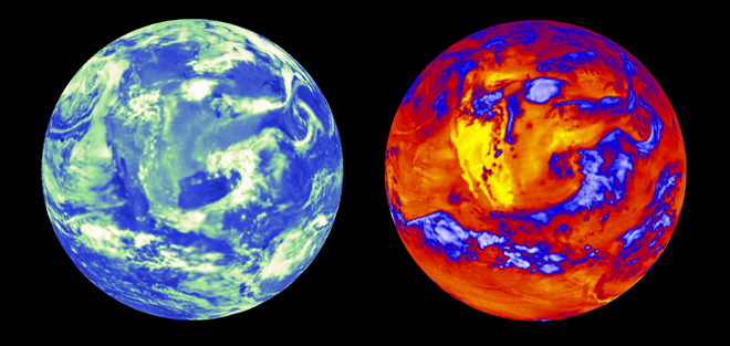
Lynn Chandler Chris Rink IMAGE ADVISORY: EARTH FROM SPACE NASA’s latest Earth Observing System (EOS) satellite, Aqua, is dedicated to advancing our understanding of Earth’s water cycle. Launched on May 4, Aqua’s multiple instruments produce data and images that are crucial toward improving our knowledge of global climate change. The Clouds and the Earth’s Radiant Energy System (CERES) instrument is one of six on board the Aqua satellite. CERES detects the amount of outgoing heat and reflected sunlight leaving the planet. A detailed understanding of how clouds affect the energy balance is essential for better climate change predictions. These Aqua images show CERES measurements over the United States from June 22, 2002. Clear ocean regions, shown in dark blue on the left image, reflect the least amount of sunlight back to space. Clear land areas, shown in lighter blue, reflect more solar energy. Clouds and snow-covered surfaces, shown in white and green, reflect the greatest amounts of sunlight back to space. Clear warm regions, shown in yellow over much of the western U.S. on the right image, emit the most heat. High, cold clouds, shown in blue and white, significantly reduce the amount of heat lost to space. Aqua is part of NASA’s Earth Science Enterprise, a long-term research effort dedicated to understanding and protecting our home planet. Through the study of Earth, NASA will help to provide sound science to policy and economic decision makers so as to better life here, while developing the technologies needed to explore the universe and search for life beyond our home planet. Images courtesy of the CERES Science Team at NASA Langley Research Center. |
CERES First-Light Images
News Date:
Wednesday, July 31, 2002
News Type:
News Link:
https://earthobservatory.nasa.gov/images/2654/aqua-ceres-first-light